
Site plan vs survey Florida is one of the most common sources of confusion I see from Florida homeowners. Many people don’t understand the difference between a site plan vs survey Florida requirements, and which document is actually needed for permit approval.
Short answer: they’re different documents, both can be useful, but most Florida permit applications require a site plan, not a survey.
What Is a Property Survey?

A property survey is a legal document prepared by a licensed Florida Land Surveyor and Mapper (LS&M) under Florida Statute 472. The surveyor physically visits your property, uses precision instruments to locate your actual property corners, and produces a document certifying the legal boundaries of your lot.
A survey:
- Establishes the legal location of your property lines
- Shows any encroachments (structures that cross property lines)
- Identifies easements by actual measured location
- Shows the location of existing structures relative to property lines
- Is a legal document on which the surveyor stakes their license
Cost: $400–$900 for a standard Florida residential survey. More for larger or irregular properties.
Timeline: 1–3 weeks typically. Can be faster.
What Is a Site Plan?
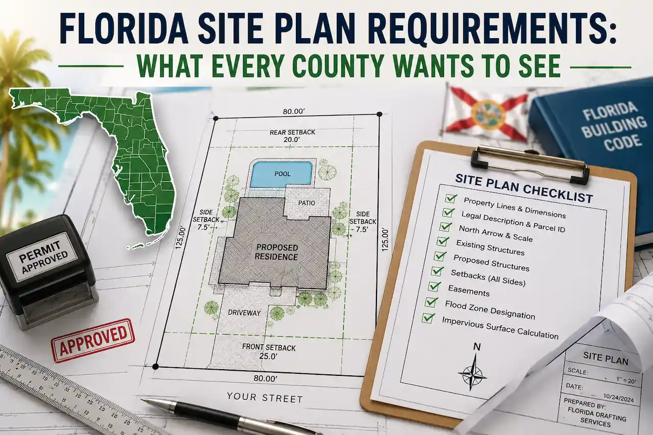
A site plan, as we’ve covered elsewhere, is a scaled overhead drawing prepared for permit purposes showing your lot, existing structures, and proposed project with setbacks.
A site plan uses parcel data (GIS records, county parcel maps, existing surveys if available) to show the layout. It doesn’t involve physically visiting the property or using surveying instruments.
Understanding the site plan vs survey Florida differences helps homeowners choose the correct document for permit approval.
Cost: $79 for a standard residential site plan with us.
Timeline: 12–24 hours.
Key Differences
| Survey | Site Plan | |
|---|---|---|
| Prepared by | Licensed Land Surveyor (LS&M) | Drafter, architect, PE, or specialized service |
| Legal status | Legal boundary document | Permit application document |
| Field measurement | Yes, the surveyor visits the property | No use of existing records |
| Cost | $400–$900+ | $79 with us |
| Timeline | 1–3 weeks | 12–24 hours |
| Required for | Boundary disputes, title insurance, and some permits | Most Florida building permits |
Do I Need a Survey for My Florida Permit?
For most Florida residential permits: No.
Florida building departments require a site plan. They do not typically require a current survey unless there’s a specific reason to question the property boundaries (like a boundary dispute or an unusual lot).
In most cases, site plan vs survey Florida requirements clearly show that a site plan is sufficient for permit submission.
Some Florida counties, notably some municipalities in Broward, do request a survey as part of the permit package. But this is the exception, not the rule.
When a survey adds value for a permit:
If your lot is irregular, has unclear boundaries, or has existing structures whose exact locations are uncertain, having a survey makes the site plan more accurate. A site plan based on a current survey is the most accurate version. We can incorporate your survey data into the site plan.
The confusion around site plan vs survey Florida often leads to unnecessary delays in permit processing.
If you don’t have a survey, we use county GIS parcel data. For the vast majority of standard Florida lots, GIS data is accurate enough for permit purposes.
What If I Have an Old Survey?
Old surveys (more than 5–10 years old) can still be useful as a reference the property boundaries generally don’t change. But if structures have been added since the survey was done, those won’t be reflected. We combine the old survey data with current satellite imagery to capture anything that’s been built since. However, understanding site plan vs survey Florida rules ensures you don’t rely on outdated documentation.
Many homeowners search for site plan vs survey Florida when trying to figure out what their building department actually requires.
Bottom Line
You almost certainly need a site plan for your Florida building permit. You probably don’t need a new survey unless your building department specifically requests one.
If you’re unsure what’s required for your specific project and county, use our Permit Drawing Package Finder to identify the plans and documents you need.
Still have questions? Contact us directly, and our team will help you determine the correct permit requirements for your project.